“The whole of life itself expresses the blues. That’s why I always say the blues are the true facts of life expressed in words and song, inspiration, feeling and understanding. The blues can be about anything pertaining to the facts of life.” Willie Dixon
https://youtu.be/Vzmfn4Xi8XE Take a journey back to a St. Louis that time almost forgot. In this video, we restore and explore the transformation of the Gateway City from 1910 through 1930.
“This is a blues story. The blues are a simple music, and I’m a simple man. But the blues aren’t a science; the blues can’t be broken down like mathematics. The blues are a mystery, and mysteries are never as simple as they look.” ― B.B. King
St. Louis served as a crucial hub for the development of early American blues and jazz between 1910 and 1930, distinct from yet connected to movements in the Mississippi Delta and New Orleans. [1, 2]
“Part of what a warrior does,the compassion and generosity of warriorship,is to get the door open and hold it open for other people to come through.That means the warrior is often out there alone. Sometimes the door closes behind you and you don’t know it happened.Then you have to stop,put the guitar down,go back and get a wedge,and get the door open again,so..people can hear the music. You can’t be afraid,no matter what’s going on.” Taj Mahal
From the “Big Cincos” on Westmoreland Place to the bustling industry of the riverfront and the quiet morning light on Lemp Avenue, we see a city of stone, steam, and incredible resilience. Experience the transition from horse-drawn wagons to the Ford Model T, witness the construction of landmarks like the Homer G. Phillips Hospital, and see the faces of the people who built the spirit of St. Louis.
“The blues ain’t nothing but a good man feelin’ bad.”
https://open.spotify.com/track/5hZw99119THbmX0fdT4z2O?si=742014fb4f1f4419 Bing Crosby … and Orchestra…. Chapters 0:00 Cahokia rises 0:47 The Big Quiet 0:59 Explorers 1:19 French Illinois 1:31 St. Louis is founded 1:51 Spanish St. Louis 2:08 Battle of St. Louis 2:18 Three Flags Day 2:29 Lewis & Clark 2:40 Steamboats 3:07 The Great Fire 3:18 Railroads 3:28 Dred Scott 3:40 Civil War 3:53 Fourth City 4:04 Eads Bridge 4:18 Forest Park 4:29 Budweiser & Union Station 4:48 The Great Cyclone 4:58 1904 World’s Fair 5:20 Spirit of St. Louis 5:43 Hooverville 5:56 Peak St. Louis 6:21 Gateway Arch 6:39 Pruitt-Igoe 7:04 The Great Flood 7:14 Modern St. Louis 8:00 St. Louis today 8:16 All 1,226 years from one spot
7/24/30 Cab Calloway and the Missourians 1929-1930 JSP Records 328. This is gorgeous version of St. Louis Blues, in which Cab soars vocally, holding one note forever and then proceeding to the next one without drawing a breath! Both the lyrics and melody are changed radically from the usual arrangement. The most famous renditions of this song are by Bessie Smith and Louis Armstrong. Cabell “Cab” Calloway III (December 25, 1907 — November 18, 1994) was an American jazz singer and bandleader.
“Music doesn’t lie. If there is something to be changed in this world, then it can only happen through music.”
Facts • Around 1100, Cahokia, just across the river, was home to an estimated 15,000–20,000 people: the largest city north of Mexico. I, Tim Flanagan, lived in Cahokia for a while… between 1953 and 1954 • Monks Mound is about 100 feet tall and holds roughly 22 million cubic feet of earth, all carried in by hand. • St. Louis was founded in February 1764 by fur trader Pierre Laclède and his teenage stepson, Auguste Chouteau. • The 1780 Battle of St. Louis was the westernmost battle of the American Revolution. • The Great Fire of 1849 destroyed 23 steamboats and about 430 buildings; cholera kil*led about 4,500 people the same year. • In 1870 the census ranked St. Louis as America’s fourth-largest city, a count Chicago loudly disputed. • The city’s population peaked at 856,796 in 1950. About 278,000 people live there today. • The 630-foot Gateway Arch was completed on October 28, 1965. “I been in the blues all my life. I’m still delivering ’cause I got a long memory.”
What Happened To St. Louis Missouri?: America’s Fastest Shrinking Large City…
“Everybody started callin’ my music rock and roll, but it wasn’t anything but the same rhythm and blues I’d been playin’ down in New Orleans.” Fats Domino
This St. Louis timelapse is part of my city timelapse series. Population figures marked ≈ are estimates; Cahokia-era numbers are archaeological estimates. How it was made: a stylised 3D reconstruction. Rivers, bluffs, landmarks, events and population figures follow the historical record; streets and buildings are generated to match each era’s documented growth.
“Jimi Hendrix came from the blues, like me. We understood each other right away because of that. He was a great blues guitarist.” Miles Davis
https://youtu.be/lzn4p-zehGM Mill Creek, St. Louis, 1955: The REALITY Before the City Erased It Market Street, Pine, Lawton, Laclede, Bernard Street, Jefferson Avenue, Union Station, Vashon High. By the Second World War about 20,000 people, most of them Black, lived in Mill Creek Valley, some 450 acres of brick row houses, storefronts and churches just west of Union Station. On Monday, February 16, 1959, a crane swung an iron ball into the first house, at 3518 Laclede Avenue.
This is Mill Creek from the inside, in 1955: one working day on Bernard Street by the clock, as Vivian Gibson set it down in her memoir, and the house her grandmother bought in 1950 for $1,400. Where sources disagree, you get every version. Two numbers I could not find: a month’s rent, and what a family was paid to move. “The reflection of the world is blues, that’s where that part of the music is at. Then you got this other kind of music that’s tryin’ to come around.” Jimi Hendrix
“Blues is a natural fact, is something that a fellow lives. If you don’t live it you don’t have it. Young people have forgotten to cry the blues. Now they talk and get lawyers and things.” Big Bill Broonzy https://www.brainyquote.com/quotes/big_bill_broonzy_265008
📌 What you’ll learn • How the valley came to be: a mill on a creek in 1765, the Union Station of 1894, the 1916 vote on a segregation ordinance (52,220 to 17,877), and the families who came up from Arkansas, Mississippi and Alabama • A city inside the city: the People’s Finance Building at Jefferson and Market (91 offices, opened 1926), the Glass Bar in the Midtown Hotel at 2935 Lawton, and forty-odd churches, counted four different ways • Two views of the same houses: more than half without running water and 80 percent without a bathroom indoors, by a later Post-Dispatch account that names neither the survey nor its year; a former resident’s answer, “We had a toilet in our house”; and the $110 million bond issue of May 1955 • The clearance and the ground today: February 16, 1959; 54 blocks, about 5,600 housing units, 800 businesses and 40 churches; 1,772 families and 610 single people by one count, against the usual 20,000; a plan for industry, housing, Saint Louis University and an expressway; and the Pillars of the Valley memorial, extended to a mile in April 2026
https://youtu.be/kPvxp4B0H_I Four streets on the north side of St. Louis — Saint Louis Avenue, Easton, Sarah and Taylor — boxed in by restrictive covenants that started in 1911 and made the Ville one of the few districts a Black family could buy into. It went from 8% Black in 1920 to 86% by 1930. Inside that rectangle: Sumner High School, founded 1875, the first high school for Black students west of the Mississippi — and the school that produced the father of rock and roll, the queen of rock and roll, an opera singer, a heavyweight champion and a comedian. Homer G. Phillips Hospital opened February 22, 1937 with 52 Black physicians on staff by 1939, took more than half of all the Black medical graduates in America, and by 1961 had trained more Black doctors and nurses than anywhere on earth. The city closed it in 1979. Tell us in the comments about the school in your neighborhood — and the teacher’s name. — Henry, Sweet Old America
https://youtu.be/YCL-ybatSnY 0:00 Missouri’s hidden Mafia history 1:44 The Last Chance Saloon state-line legend 3:36 Villa Capri and the casino skimming wiretap 5:39 St. Louis factions and the bombing war 10:40 The River Market power struggle 13:36 The Union Station Massacre and the FBI 15:52 John Lazia and Pendergast’s political machine 20:30 Charles Bonagio’s unsolved murder
What do ordinary buildings in Missouri reveal about organized crime, political power, and unsolved murder? I take you through ten real locations connected to the Kansas City and St. Louis Mafia, from a bar built across the Missouri–Kansas state line to the site of a mob killing beneath a portrait of President Harry Truman.
I cover the Last Chance Saloon, the Villa Capri wiretap and its connection to Las Vegas casino skimming, the St. Louis bombing war, and the River Market’s violent struggle for control. I also look at the Union Station Massacre, John Lazia, Tom Pendergast, and the political machine that helped launch Harry Truman’s career.
https://youtu.be/SOxDMDfR6-g?si=3TC9MyT7C9spt1RS Discover 50 facts about Missouri history, from early Native American settlements to the legends that shaped the state. Missouri natives have a rich story that stretches from the banks of the Mississippi River to the depths of the Ozark forests. We are tracing the timeline of the Show Me State, starting with the original inhabitants who farmed the land and navigated the waterways long before the arrival of pioneers. This collection highlights the cultural shifts, historical figures like Abraham Lincoln, and the crucial sites that define the region today. Whether you are interested in Native American history or the evolution of the frontier, these 50 points cover the essential moments that built Missouri.
https://youtu.be/pZwgYBaIknw?si=Pc2Nr1TDr9c-pvZ9 Missouri isn’t just Chiefs football and Cardinals baseball. It’s billion-year-old mountains, the most powerful earthquake zone east of the Rockies, the largest spring in the United States, and a man-made lake with more shoreline than California. In this video, we break down 50 insane facts about Missouri — from the roaring New Madrid earthquakes that made the Mississippi River flow backward, to the underground cave systems that earned the state the nickname “The Cave State,” to the loudest stadium ever recorded on Earth. But this isn’t just geology. It’s beer empires in St. Louis. Route 66 nostalgia. Silver Dollar City built over a 500-foot cave. The Gateway Arch towering 630 feet above the Mississippi. And 80,000 Chiefs fans literally shaking the ground. Missouri doesn’t brag. It just quietly sits on some of the most extreme geography in America — and a culture built directly on top of it
The Tragic Life of the “Infected” Daughter of Ozarks (1904)Along the way, I show how these locations connect organized crime to labor unions, gambling, elections, and the expansion of the FBI—and why so many of them look completely ordinary today.
https://youtu.be/mMoUVZBNYtE?si=vCODd6fX-vb8fpqd Missouri’s rolling hills, river towns, and quiet highways hide some of the darkest legends and unsolved mysteries in the United States. In this video, we descend into Missouri’s eerie folklore—where unexplained disappearances, terrifying creatures, haunted locations, and forgotten towns leave behind chilling questions.
https://youtu.be/q05Abpvd9k4?si=nH0qlc270lwGLcUh Long before Missouri became the state we know today, a handful of small settlements were quietly laying the foundation for everything that followed, and this video counts down the oldest towns in Missouri that still exist and thrive to this day. We dig into the real history Missouri towns, exploring how these communities survived floods, wars, and centuries of change while holding onto the character that makes them so unique. Each stop on this list highlights a different chapter of Missouri founding history, from early French and Spanish settlements along the rivers to the pioneer towns that shaped the state’s identity during westward expansion. If you love historic Missouri towns, oldest cities in Missouri, or the deeper story behind Missouri river towns, this video connects the dots between the past and the present in a way that’s easy to follow and genuinely fascinating. Beyond the history itself, we also touch on American frontier history more broadly, showing how these historic small towns America still treasures reflect a larger story about how the country grew one settlement at a time. Whether you’re planning a trip through Missouri travel destinations, researching Missouri historic sites for a project, or simply love small town America history, this countdown is packed with stories you won’t want to miss. #Missouri#MissouriHistory#HistoricTowns#SmallTownAmerica#USHistory
https://youtu.be/kpvBc58GTBc?si=Vlhfdm1Y_8u2SVog In 1878, a wagon train carrying over two dozen travelers entered the Ozark Mountains — and was never seen again. No bodies. No wagons. Only a trail that ended in the middle of nowhere. More than a century later, locals still whisper about what really happened that night.
https://youtu.be/tg8bUt7mV6s Welcome to this story, one of the most unsettling cases ever noted in the Ozark Mountains.In 1915 Mary Thomas was found frozen in the wilderness—her body stiff with ice, yet she was somehow still breathing. Doctors were baffled, and the case quickly became one of the region’s most disturbing mysteries.
https://youtu.be/NRZtvBXJxRY?si=vO6SYPzBh_ZI4z5a The Macabre History of the Mountain Witch of Black Hollow — Her Curse Still Lives (1892, Missouri Ozarks) In 1892, deep in the Missouri Ozarks, a woman named Elin Hatchard was accused of witchcraft after a series of strange tragedies in a mining town. Locals believed she cursed the land before disappearing into Black Hollow — and for more than a century, terrifying stories of her vengeance have refused to die.
Known Underground Networks in St. Louis
Caves & Brewery Tunnels: The Missouri Speleological Survey has documented about 38 remaining natural caves beneath the city (such as Cherokee Cave and English Cave), many of which historical 19th-century breweries used to store beer. [1, 2]
River des Peres Conduits: The largest underground water system is the River des Peres tunnel network, which runs for miles—including a 6-mile stretch buried in large concrete tunnels beneath Forest Park managed by the Metropolitan Sewer District (MSD). [1, 2, 3]
Various historical basements, utility corridors, and old brewery passages exist near Washington Avenue, though most are not open to the general public. [1, 2, 3]
Beneath parts of St. Louis, enormous vaulted rooms and former caves still hold traces of breweries that disappeared generations ago: iron hoops from collapsed beer tanks, hose fixtures, channels that carried away melting ice. People walk overhead with little reason to suspect what survives beneath their feet.
On October 15, photographer Jason Gray and historian Chris Naffziger took us on a tour of some truly unseen places. Their talk revealed brewery cellars, caves, and tunnels most of us will never enter, along with old sewers and the working spaces hidden inside the Saint Louis Art Museum.
Keeping St. Louis supplied with beer once required extraordinary work underground. At the Lemp Brewery, workers dug into the bedrock, built enormous vaulted cellars, and hauled in huge quantities of ice to keep the lager cold. They even left an opening where they could continue digging as the brewery grew. Mechanical refrigeration eventually saved them the trouble.
Those cellars survive roughly 50 feet below ground, with seven parallel barrel vaults that Chris considers among the city’s most remarkable interiors. But photographing them took some work. With Chris operating the shutter during a long exposure, Jason walked through the chambers, lighting each one in turn. He couldn’t wear a headlamp without its light appearing in the photograph, so he had to find his way between the bays in complete darkness.
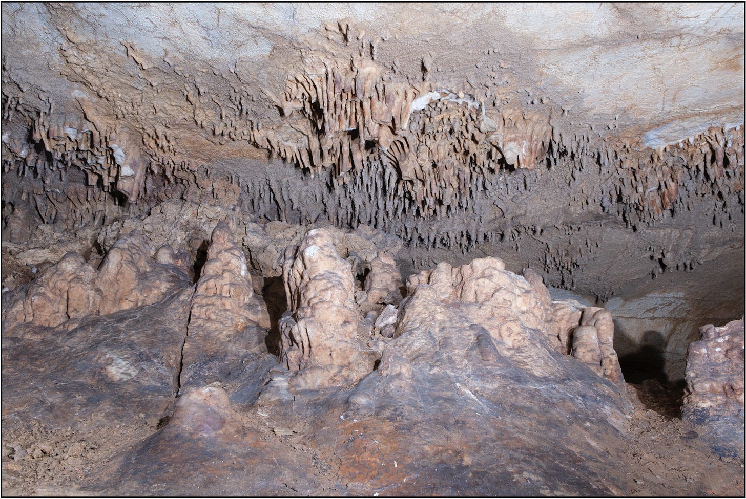
The brewery also used Lemp Cave, part of the larger system associated with Cherokee Cave. Although it began as a natural cave, brewers quarried out an estimated 85 to 90 percent of the Lemp portion to make more room. Water has since continued depositing minerals on the surfaces they reshaped for beer storage.
The family’s supposed underground theater has become part of local lore. The so-called theater room has painted walls and lights often described as stage lighting. But as Chris pointed out, the lights face toward the supposed audience. Their origin remains uncertain, and Jason hopes to bring in a conservator to help determine when the walls were painted.
Part of the challenge is figuring out which changes the Lemps made and which came later. When Lee Hess developed Cherokee Cave as a commercial attraction, he connected previously separated sections and made his own alterations. He also gave visitors something memorable to look for: the “Black Dahlia,” a dark mineral formation named to capitalize on the notorious murder case making headlines at the time. It was a marketing gimmick, and Jason’s photographs showed that the formation is still there.
What survives reflects several generations of people using the cave in different ways, from storing beer to selling tickets. Sorting out those layers helps us understand what visitors would have seen during each period.
Neither Cherokee Cave nor Lemp Cave is open to the public today. These photographs gave us a rare chance to see what remains, including details that might help separate history from story.
Earthbound Brewing. Photo by Jason Gray.
Cherokee Brewery: A different underground story
Cherokee Brewery, at Cherokee Street and Iowa Avenue, later became home to Earthbound Beer. It’s unrelated to Cherokee Cave.
Before Earthbound could open, its owners had to clear demolition rubble from the old cellars and figure out what to do with the flooded lower level. Early on, they explored with an inflatable raft and climbed down two ladders fastened together. Jason’s photographs documented the cleanup as workers used a conveyor to haul dirt and debris to the surface, leaving some large fallen stones behind. Earthbound eventually used the upper level for brewing and storage, but the lower level remains unfinished.
Chris cautioned against assuming every brewery cellar began as a cave. At Cherokee Brewery, a sinkhole may have influenced the site, but the surviving rooms reflect extensive human construction.
Earthbound has since closed. The photographs preserve both the old brewery’s underground rooms and the effort required to recover them.
Uhrig’s Cave. Photographer anonymous.
Uhrig’s Cave, Winkelmeyer, and Union Station
At Washington and Jefferson avenues, Uhrig’s Cave once promised entertainment. Anonymous photographs revealed surviving chambers beneath the former Uhrig’s Cave site, with stone walls, brick vaults, and floor channels to carry away water from melting ice. The St. Louis Coliseum later occupied the site, followed by the Jefferson Bank building associated with the city’s civil rights protests. The cellars remained below.
Near Union Station, the Winkelmeyer Brewery was once a major competitor, larger than Lemp and Anheuser-Busch for a time, Chris explained. The Central Post Office occupies its former brewery site, while lagering cellars survive nearby beneath the Gateway Mall.
Photographs showed vaulted rooms, water marks on the walls, and metal fixtures that once supported hoses. Large stationary vessels held beer, which workers pumped in and out through a process called racking.
Chris also challenged stories about an underground beer railway crossing downtown. When these breweries began, they stood near the city’s edge. Brewers could move beer by wagon to outlying storage cellars without building elaborate underground routes.
We also saw photos of tunnels beneath nearby Union Station. The station above welcomes visitors; these passages do not. Together, the photographs revealed extensive surviving spaces without proving the single interconnected underground world of local legend.
Home Brewery: What the tanks reveal
At the former Home Brewery in Marine Villa, piles of wood and iron tell a story missing from many empty brewery cellars.
They are the collapsed remains of lagering tanks. Their wooden components and enormous metal hoops reveal the equipment’s materials and scale. Overhead fixtures mark where racking hoses once ran.
Cave historians Hubert and Charlotte Rother documented the cellars during the brewery’s demolition. The newly shared photographs showed surviving spaces on two levels, with the lower level described as unsafe to enter.
Sewers and water treatment
Jason traced the development of public sewers to the cholera epidemic of 1849, when residents blamed polluted Chouteau’s Pond and other foul accumulations for the disease. Draining the pond raised questions that extended beyond engineering: who would build a public system, maintain it, and pay for it?
He mentioned the conversion of the Biddle sewer from private to public use before turning to the Mill Creek Sewer, whose watershed extends far beyond the old pond.
Historical photographs showed workers enlarging Mill Creek in the early twentieth century, followed by a banquet inside the completed work in 1916. For its organizers, the enormous interior demonstrated a civic achievement worth celebrating. Modern photographs showed the working sewer after a lining project covered its older masonry. At the riverfront, pumping infrastructure helps manage water arriving from the city and the threat of a rising Mississippi.
One of Jason’s most striking discoveries was an unfinished predecessor. A tip about a stone-walled room beyond a narrow brick tunnel initially suggested an icehouse or storage chamber. Research instead pointed to an early attempt to drain Chouteau’s Pond.
Workers had abandoned the larger project after encountering quicksand. Thin limestone courses and timber flooring survived in the disconnected construction. Jason has withheld its precise location to protect it.
A failed project preserved an extraordinary piece of the city’s early infrastructure.
River Des Peres tunnel + waste agitation at Lemay Wastewater Treatment Plant. Photos by Jason Gray.
Beneath Forest Park, the River des Peres flows through enormous enclosed passages. Jason traced efforts to contain it through changes associated with the World’s Fair and the major floods that followed.
Inside the twin tunnels, one passage shown measured about 32 feet in diameter. Impressions left by wooden construction forms remain visible in the concrete.
He followed the system to the Lemay pumping station and Lemay Wastewater Treatment Plant, where photographs documented removing solids, skimming fats, and treating wastewater before returning it to the Mississippi.
We usually hear about this infrastructure when something fails. Jason’s photographs showed the system’s scale and the people whose daily work keeps it running.
Cleaning the Apotheosis. Photo by Jason Gray
Behind the scenes at the Saint Louis Art Museum
In a slight departure from the “underground” theme, Jason also revealed hidden spaces in a building many of us know well.
He has worked in several roles at the Saint Louis Art Museum since 2002. His photographs showed conservation laboratories tucked into the hillside, mechanical rooms, and a tunnel beneath Sculpture Hall. When a fountain operated in the hall, its switch was in that passage.
During conservation of Elmer Garnsey’s mural near the former library, workers discovered the artist’s signature behind casework. Cleaning also released an unexpected trace of the museum’s past: as conservators worked through old deposits, the smell of tobacco smoke returned.
These photographs made visible the work supporting the galleries, much of it behind doors or beneath visitors’ feet.
English Cave: Ongoing research and exploration
At English Cave, also known as McHose and English Cave, equipment has gone where researchers themselves cannot.
East of Benton Park, roughly 45 feet underground, the cave served as beer storage in the 1830s, Chris explained. Over time, the site also drew visitors for recreation, and later occupants grew mushrooms underground. Eventually, entrances disappeared beneath alterations and fill.
No one can currently enter English Cave. In March 2020, researchers drilled narrow holes and lowered cameras and LiDAR equipment, confirming that substantial cave space survives. A separate excavation is investigating an old access used by mushroom growers.
Bill Kranz described the next steps. As of the talk, the project had raised $6,000 toward enlarging a borehole and needed another $8,000. A wider opening would accommodate robotic equipment to investigate areas not yet adequately examined.
The long-term ambition is a staircase and guided public access, which will require much more work, funding, and coordination. People can help the recovery effort now without entering the cave.
None of the underground or behind-the-scenes spaces featured here are currently open to the general public. That made this evening unusual: a chance to see places most of us otherwise know only through rumors, maps, or old photographs.
The details tell their own stories. Drainage channels reveal melting ice. Metal fixtures mark vanished beer hoses. Wooden tank fragments explain enormous rooms. Concrete carries the impressions of workers’ construction forms.
Thank you to Jason Gray, Chris Naffziger, Bill Kranz, the anonymous photographic contributor, and everyone who joined us at Leviathan. Thanks also to Michael McKinley of the St. Louis Public Library, who brought examples of cave-related materials available in Special Collections at Central Library.
You can view many more photos in Jason and Chris’s presentation below:
Updated Underground St Louis Jason Gray And Chris Naffziger
The Unseen STL History Talks continue this fall at Leviathan Books.
On November 19th, we will welcomeDevin Thomas O’Shea for a conversation about the Veiled Prophet Society, the history that led to its creation, and the controversies and protests along the way. This talk will allow time for questions and discussion, so you won’t want to miss it. We will have a limited number of advance tickets available, so subscribe to Unseen St. Louis to be notified when they become available.
In December, we will skip the regular monthly talk and gather instead for Brick the Halls: A St. Louis History and Preservation Holiday Celebration on Monday, December 14, at Clements on Cherokee. Rather than a presentation, this informal evening offers an opportunity for people interested in history and preservation to meet one another, connect with local organizations, and learn how to get involved. We will have snacks and a cash bar. More details are coming soon.
The Underground Rivers & Infrastructure
River des Peres: Originally a winding natural river flowing through Forest Park, it was turned into an open sewer and later permanently buried between 1924 and 1930 into massive 30-foot-wide concrete tunnels managed by the Metropolitan St. Louis Sewer District (MSD). [1]
Deep Tunnels: MSD also utilizes deep-rock tunnel systems (150 to 200 feet underground) with hundreds of millions of gallons of storage capacity to handle combined stormwater and wastewater. [1]
Safety & Access: Reddit users on r/StLouis agree that exploring the underground River des Peres is extremely dangerous due to rapid flash floods and high water levels during storms, and access points are strictly locked and off-limits. [1, 2]
Natural Caverns and Karst Topography
Cliff Cave: Located in Cliff Cave County Park in South County, this is a 4,000-foot-long natural limestone karst cave. It is gated to protect a colony of endangered Indiana bats and is only accessible via seasonal, ranger-guided events. [1]
Historical Uses: In the 19th and early 20th centuries, German immigrants and local breweries (such as the Lemp Brewery and Uhrig’s Cave) utilized natural limestone caves for pre-refrigeration beer lagering, beer gardens, and private connecting tunnels. [1, 2]
Cherokee Caves & Lemp Mansion Caves: Historic commercial cave systems and cellars run beneath parts of the South City neighborhoods, though many are sealed, private, or hazardous to enter. [1, 2]
Watercolor painting by Anna Maria von Phul, “A View of a Cave, 2 Miles from St. Louis, Missouri Territory”, 1818
The caves of St. Louis have been important in the economic development of St. Louis, Missouri, United States. The city was built upon a complex of natural caves which were once used for the lagering of beer by early German immigrant brewers. Caves are naturally cool, which was especially attractive to brewers before the advent of refrigeration.[1]
Breweries
Uhrig’s Cave beer garden, ca. 1870
Several breweries were built atop these natural caves, which were altered to suit their purposes. Stone arches and brick ceilings prevented water seepage and uneven cave floors were paved with brick. In addition to being used for the storage and lagering of beer, such naturally cool places were sometimes employed as beer gardens, places for entertainment.
John Adam Lemp, coming to St. Louis from Germany in 1838, started a brewery using natural caves for refrigeration. His son William J. Lemp took over the business and built the Lemp Brewery industrial complex which still stands in St. Louis.[2] The Lemp Mansion was constructed by the Lemp Family and included a tunnel through the natural cave system leading to the Lemp Brewery. The Lemp Family would use this tunnel to go to work.[2]
Underground Railroad
An oral tradition in St. Louis links the cave system with the Underground Railroad. According to this tradition a tunnel behind the house at 3314 Lemp Avenue was used as a secret entrance to the caves. One entrance to the caves opens near the Mississippi River, where the slaves could make their way to freedom.[3]
Cherokee Caves
Commercial building for the Cherokee Caves. Photo taken in the 1940-50s.
Old caves were often filled with rubble from the demolished buildings above them. Therefore, there may be many homes and houses currently built above entrances to the old system of caves which have since been filled in with rubble. The Lemp caves or Cherokee caves still exist.
Meramec Caverns, the oldest attraction on Route 66, offers guided tours of the rarest and largest cave formations in the world.
Located in the foothills of the Ozark Mountains, southwest of St. Louis, the cave sheltered Native American tribes and later provided minerals to French colonial miners. Civil War garrisons used the cave’s deposits to manufacture gunpowder, and outlaw Jesse James hid both men and horses in the cave’s dark passages in the 1870s. Legend also says the cave was a stop on the Underground Railroad.
Adventure seekers can also explore other caves near St. Louis at Onondaga Cave State Park or canoe along the scenic Meramec River and the crisp Huzzah and Courtois creeks.
ST. LOUIS, Mo. (First Alert 4) – It’s a rare look at a vital part of St. Louis that you rarely get to see, the 10 thousand mile maze of sewers below the city.
FirstAlert4 had an opportunity to visit a small chamber within that network, a section running under Forest Park.
Sean Stone, who works with the Metropolitan Sewer District’s Project Clear, took FirstAlert4’s Nathan Vickers into the tunnels, which are normally locked and off-limits to the public for safety reasons.
“You don’t want to come down here,” Stone cautioned. “It’s not safe. If there were a storm this would fill up in minutes.”
On Wednesday, the dry weather meant that the stormwater stream, which collects runoff from areas North and West of Forest Park, was only a trickle, offering a glimpse into the vast underground caverns.
“All of this stuff comes together here and goes downstream to the Lemay water treatment plant,” Stone said.
The tunnel is technically the modern-day River Des Peres, which was first moved underground prior to the 1904 World’s Fair to help with flood control. After the fair, it was brought back up, only to be buried again nearly 20 years later.
Amanda Clark, a public historian with the Missouri History Museum, said it was considered an incredible feat of infrastructure at the time. There is a plaque in the park commemorating the civil engineers who worked on the project, partly because of the way it connects with other drainage infrastructure in the city.
“It’s something that people a century ago had big plans that came into action that help our city today,” Clark said. “There’s always history hiding where you don’t expect it.”
Watch more of the tour in the video attached to this story.
You can also see photos from the Missouri History Museum of the construction of the tunnels on the River Des Peres. The museum is currently developing an exhibit on the river as part of a larger project showcasing the 150th anniversary of Forest Park.
https://youtu.be/vBILt-LEnp0?si=rmMF4up6YAbFhCXS In the late 1980s, Timothy Duffy, a penniless North Carolina musicology student, set out to document and preserve traditional southern roots and blues music. On his travels from Winston-Salem’s drinkhouse music scene, an off-the-grid hotbed of gritty traditional blues, to deep-south family run churches, he found purpose and inspiration from a cast of amazingly talented, pure and unique set of characters (the artists!!). Toot Blues remarkably captures the true essence and talent of the artists from Guitar Gabriel, a ‘homeless magic potion selling’ blues genius; to Willa Mae Buckner, a snake charming elderly woman taunting delightfully raunchy blues; to Beverly ‘Guitar’ Watkins, a grandmother who continues to tear up the stage and play a killer electric guitar behind her head; to Bishop Dready Manning and family churning out homebrewed rockabilly-gospel; to Boo Hanks, an 80 year-old bluesman recording an album for the very first time; to blind guitarist, Cootie Stark, mesmerizing crowds world-wide while never failing to find his way home by himself. Shortly after befriending and championing for these artists Tim quickly realized the limitations set upon them by living in poverty, not only in their struggles to survive and support their families but also their ability to afford time and outlets to continue with their deepest passions-music, by a simple twist of fate, Tim along with his wife Denise, began the Music Maker Relief Foundation. With rare footage, interviews, and numerous live performances, the film documents these unique musicians, brought together through the Music Maker community and their shared and vital musical heritage.https://youtu.be/xyUgj4TBdpY?si=rq4a-xHviqDx4S3q A powerful documentary starring Morgan Freeman about the genesis of The Blues in the South and the music spreading around the world. Morgan Freeman shares his story of his experience of growing up in Clarksdale, Mississippi and his love for the Blues. Director: Scott A. Jennison Writer: Scott A. Jennison Starring: Morgan Freeman, Seasick Steve
https://youtu.be/ng2_pBIrlGQ This video details the wild and crazy gang wars that St Louis has had through the years. Starting from the turn of the century with the Egan’s Rats battling the Bottoms Gang and then having to turn around and fight the Hogan Gang. Then the royal rumble of gangland warfare with the Cuckoo gang, the Pillow Gang, the Sicilian gang called the “Green Ones” and the breakaway faction called the Russo Gang all going at it on the blood soaked streets of St Louis. This video also covers the factional wars of the early ’80’s after the St Louis mob boss Tony Giordano died, with the Leisures vs Jimmy Michaels gang, which included devastating car bombs being detonated left and right causing havoc in St Louis.
https://youtu.be/K8qs3VVWKq4?si=h-aDrmBtVl6KHl8c – “The Flamboyant Years: St. Louis in the Twenties” (1962). This film visits the people, places and events that made this era unique in St. Louis: the Cherokee Businessmen’s Street Carnival, the Veiled Prophet Ball and Parade of 1922, the 1926 World Champion Cardinals with Rogers Hornsby, the tornado of 1927 and the development of the city under Mayor Henry Kiel.
https://youtu.be/rpsgD3mBL5U This documentary explores the rise and fall of St. Louis city’s most infamous drug kingpins of the 1970’s. From the project walls of the Pruitt-Igoe housing complex and surrounding areas, to notorious figures in the heroin trade. Major figures like ‘Fats’ Woods, Terry Joe Cooley, T.J. Ruffin, Duke Brock, Jerry Lewis-Bey and more are explored in vivid detail.
https://youtu.be/VxcIfcVZ98Q In the 1950’s, St. Charles, Missouri was typical small town America. People shopped on Main Street as they had for over century. It was the time of Dwight Eisenhower, Howdy Doody, ducktail haircuts, and malt shops. “Our Town: St. Charles” shows the community as it was before the advent of interstate highways and shopping malls. This film’s 61 minutes of black and white footage recalls a quieter time of not so long ago.
https://youtu.be/QyWLmpNMChY Much like Chicago and New York, St Louis will require several videos to cover the amazing architecture found within. In this video, we take a close look at a group of buildings that were supposedly constructed in the mid-late 1800’s and early 1900’s.
https://youtu.be/Zq9p31qkG0M?si=HLLXi0suUSL8NwGr St. Louis’s built landscape has been changing from the moment the city itself was born. These 50 images offer up incredible views of St. Louis’s past: Some of these streetscapes still look very familiar, and others have been so changed by the passage of time that they’re totally unrecognizable.
https://youtu.be/KIwSmVRq0xQ CHAPTERS 0:00 Intro 01:31 Beginnings of the Arch 02:44 Progress or Decay? 04:00 Baseball 04:50 Bond Issue 05:39 Pruitt-Igoe Housing Project 09:15 War Footing 10:30 The Age of the Teenager 12:06 End of Segregation 15:07 Television Broadcasts 16:40 City and County Separation 17:57 The Age of the Automobile 18:44 Urban Renewal and Mill Creek 21:25 Salem Methodist Church Changes23:27 Neighborhoods and Housing 25:50 Outro
The Delmar Divide – Segregation in St. Louis, Missouri
St. Louis has several major revitalization efforts underway, including a $230 million Rams settlement plan for North City and downtown, an $81M redevelopment of the Edison Brothers building into the Sheraton St. Louis Downtown, and new state laws creating an “Innovation Zone” for vacant buildings. The focus spans housing, infrastructure, crime reduction, and historic preservation, with projects led by the city, nonprofits like Habitat Saint Louis, and private developers.
Mayor Cara Spencer has proposed using $230 million from the Rams settlement for city-wide improvements, with $110 million earmarked for North St. Louis rebuilding and housing. The plan also includes $31M for neighborhood revitalization and small business support, $30M for water infrastructure, and $55M for downtown redevelopment. Habitat Saint Louis is already building 40 new homes in North St. Louis as part of a $17 million project with the St. Louis Development Corporation.
Governor Mike Kehoe signed House Bill 3231 to create an “Innovation Zone” that gives developers tax incentives to redevelop long-vacant downtown buildings like the AT&T Tower and Railway Exchange Building. The state also approved new incentives tied to the $670 million Millennium Hotel demolition project, which aims to better connect the Arch and Busch Stadium. Meanwhile, the Edison Brothers building is getting an $81M overhaul from Midas Hospitality and will reopen in fall 2027 as the Sheraton St. Louis Downtown, including restoration of its iconic 1904 World’s Fair mural.
Missouri’s new economic development law introduces an Angel Tax Credit Program to direct early-stage investment to Missouri-based startups and an Innovation District Framework that lets qualifying downtown companies recoup 3% of payroll for reinvestment. The angel credit is available almost immediately, but the innovation district rules may not be finalized until the first quarter of 2027. Local stakeholders say these tools address financing gaps that have held back St. Louis compared to other major markets.
Safety remains a central issue for downtown revitalization, with many residents and stakeholders saying crime perception deters investors and residents. Proposed solutions include license plate recognition cameras, smart lighting, increased police presence, and filling empty storefronts to boost foot traffic. At the same time, community groups are pushing for protections for legacy homeowners in North St. Louis as luxury rehabs rise near the new NGA campus, calling for property tax freezes and community benefit agreements to prevent displacement.